Friday, November 30, 2007

Farewell to Tasmania, your seabound coast...


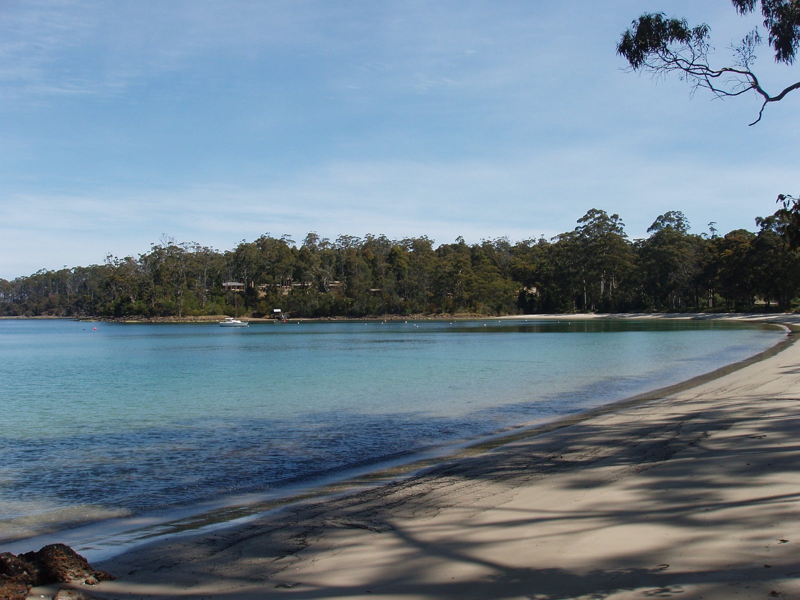
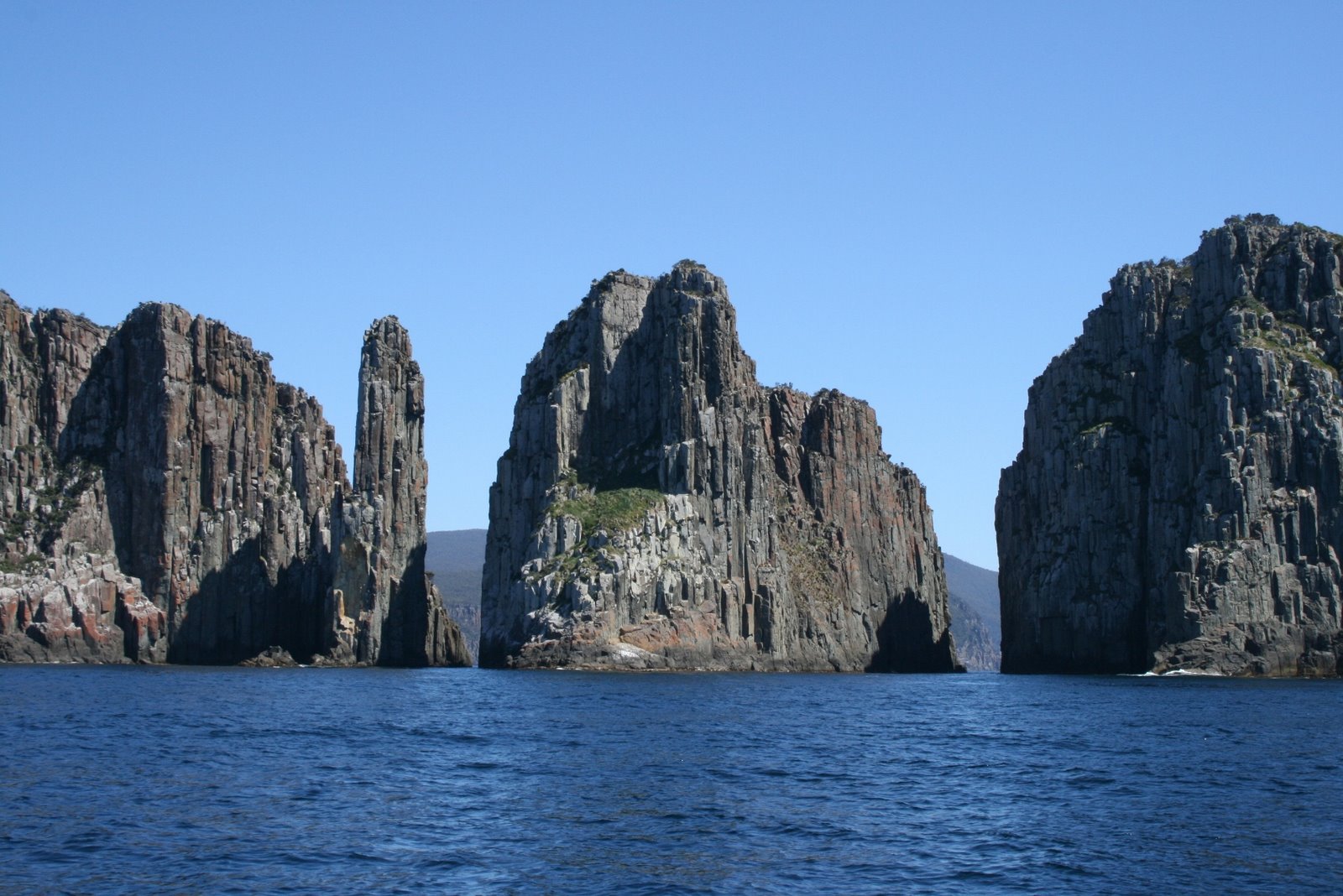
Actually, I guess that song is about Nova Scotia. Well, the similarities with Tasmania and NS are substantial, in terms of terrain, vegetation, even climate and agriculture. The North Coast of Tasmania is heavy to agriculture, including dairy products. There are bits of logging and lumbering around the state – they cut both gum trees and (introduced) pine trees. The logging trucks represent the same hazard to anyone else driving that they do at home, although the trucks and loads are a bit smaller here. The West coast is rugged and is only populated with a couple of mining towns that look fairly poor (especially when you can see the wealth associated with mining in Western Australia). South Coast is mostly about Hobart and the history of the area (photo of Hobart attached). The East Coast is more about the tourist industry than anything much else, as you can see from the beach and coast photos enclosed, it is fairly spectacular scenery. The climate on the East Coast is allegedly a bit milder than the rest of the state. I think that the latitude of Tasmania is much like Oregon, and the climate might match, as well. Anyway, definitely put Tasmania on your list of places to visit before you die.
I am a bit disappointed in the lingo here. I was expecting a vocabulary something like Newfoundland (with the Australian accent, of course), given that they are both islands somewhat remote from the mainland. However, my ear has not picked up much in the way of difference in accent here. I would say that is true around the whole of Australia: while a student of accents would pick up the differences from state to state, I have found less difference than there is from Province to Province (or region to region) in Canada. The exceptions might be in South Australia, where we found more of an accent, and the young ladies in shops who are difficult to understand, when they can be troubled to wait on you. We did notice differences in expressions: When greeting someone in Queensland, G’Day (guhDie) still prevails, where Western Australia and the Southern States are more inclined to say Howyagownmate (yes, that’s one word) and Tassy might even just say Good Morning. The younger generation might very well just say Hi, which is proof to the older generation that the Americanization of the culture continues unabated. (I have certainly noticed that happening, during my five visits over the past forty-odd years.)
We are currently in a delightful place called Deloraine (same spelling as the place in Manitoba, somewhat different climate). Sylvia spotted a hairdresser that would make an appointment to cut her hair, so we scouted out the local municipal campground, down by the river (with water in it, if a bit muddy). So, we will spend the night here, then drive the hour up to Devonport for the ferry back to the mainland tomorrow evening. The distances here are quite small, but that doesn’t necessarily mean that the travel times are, as some of the roads are very narrow, crooked and hilly. We like it that way – sort of like Ireland in some places, Portugal in others.
Not sure where/when this will get posted. Maybe later today, Wednesday Nov 28th.


Sunday, November 25, 2007

Text for earlier post

The first photo here should be of the Melbourne tram. “Melbun” tram, I guess I should say, to get the pronunciation right. We used the trams to get around while there – like we have been doing in all the capital cities, getting a caravan park near public transit, then using that to go downtown. In this case, it was about a two km hike to the tram line. The buses were right across the street, but they quit running far too early. The core of the city is much like the large Canadian cities, with substantial Asian population visible. Anyway, on the way in to the city, we went through one of the older neighbourhoods that looked intriguing (area settled substantially by those of Greek and Italian descent) so we resolved to try to jump off the tram and stop there on the way back, perhaps have supper there. So, that is what we did. We landed in the middle of one of their Saturday street markets, where the side street is blocked off to traffic, and booths and food of all sorts were available for purchase, not to mention wall to wall people. We found a restaurant back on the main street and had a very nice dinner. We did manage to get back on the tram, although did get a bit lost walking from the end of the tram line to the van park.
The crossing to Tasmania was much better than anticipated. The weather was quite calm, and the ferry itself was great. We had a two-berth cabin on the way over, and have booked a deluxe cabin for the return trip. We had a good dinner as soon as the boat sailed, then Sylvia went straight to the casino, hit on the slot machine (pokie), collected her winnings, and went off to bed.
We landed early in the morning (about 7), and could have sworn immediately that the boat had made a wrong turn and dumped us in New Zealand. Tas is as green as the rest of the country is brown. The roads are also as narrow and crooked and hilly as the others are flat and straight. Maybe this place should join NZ.
In an earlier post, I mentioned that there is some sort of quarantine between most states, preventing the importation of fruit and vegetables – seems to vary from place to place – kind of a remnant of the British Colonial bureaucracy. Well, Tasmania takes it very seriously: They have just the one point of entry for vehicles, at Devonport where the ferry lands. They have sniffer dogs to ferret out illegal fruits and vegetables. We saw them apprehend a bouquet of flowers, for which the mutt was handsomely rewarded. We are getting used to the routine and had consumed or tossed all of our fruit and vegetables, so our next stop was a grocery store to restock.
We spent our first day along the Northwest coast – very rural and agricultural, lots of dairy cows, overnighted in a neat touristy village named Stanley.
We then worked our way down the West coast, as near as you can. We went to the National Park at Cradle Mountain, did a hike around Dove Lake. (This is significant, since at 7 km, it is the longest one I have done yet. It went well enough, although we got caught in the rain and cold, and there was one section of a couple of kms that was quite steep and slippery. Progress was very slow.) The photo is of Cradle Mountain – had one with both of us in it, but got rain on the lens. We overnighted in the Park, the closest to bush camping we have done yet. Still had power, and the shower building was near at hand.
Since then, we have been working our way down to Hobart, (doing some of the short walks in the National Parks along the way) and intend to head in there today (Friday, 23rd) for a look around, maybe post this. While we were on the West Coast (actually at Arthur River) a sign noted that, if you looked straight West, you could see Argentina. It seems that at 42 degrees S, we are South of Africa.

Thursday, November 22, 2007

In Tasmania


Can't seem to move the text over, so will make do with a brief description: Melbourne Tram, Spirit of Tasmania (ferry), updated map, Cradle Mountain (National Park) and Tasmanian devil


Friday, November 16, 2007

Some quick notes from Melbourne – we are going downtown today, so will probably find a suitable internet location to do an upload.
Expedition in search of the source of the Blue Nile. No, not really. This expedition to the Barossa Valley was in search of the source of the Red Wine. We spent a bit of time wine-tasting at the very impressive Wolf Blass visitor centre. The photo is of us in front of Wolf Blass’ monument to himself. They had a number of private tasting rooms for the high rollers, but we were not invited in. I looked for the Joe W tasting room, but did not find it. It is probably even more exclusive.
The roadsign: after 21000 km, now they tell me!
Christmas in Adelaide – some of the Christmas decorations in downtown Adelaide. Early November. Does not look terribly Christmassy to us.
Blue Lake, at Mount Gambier SA. Just before we crossed the border into Victoria State. The change was gradual enough, but the difference between the draught-ridden South Australian flatland and the bright green of the primarily agricultural (sheep and cows) hills of Victoria is remarkable.
The Twelve Apostles, along the Great Ocean Road, West of Melbourne. Lots of post-card quality scenery along the coast. Not unlike driving the Cabot Trail in Cape Breton


Sunday, November 11, 2007

Red Centre,too

Maybe will work this time - different computer. This text belongs with the Red Centre photos.


We have just returned from “the Red Centre”, and are currently enjoying the sunshine and staying at a very nice Caravan Park just South of Adelaide. We will go into the city today for a look around, and maybe find an internet café to post this. I prepare it on the computer in the van, then save it to a jump drive. This place actually has wireless in the campground, so I could do it all right from here, but it looks to be a fairly weak signal, and their prices are quite high.
As Rob pointed out, you can enlarge the photos in the weblog by clicking on them. It figures that a Mac guy would discover the intuitive, simple stuff.
Anyway, the Red Centre: We were quite impressed with Alice Springs – “The Alice” – had kind of expected it to be flat, hot and dry – sort of a bigger Tennant Creek. The city is surrounded by rocky ridges – not really mountains, they refer to them here as “ranges”. Many of the lawns were green (okay, we were there in the spring. I am not sure what they look like in February, when the temps are in the mid-40s). I would compare it to Terrace, in terms of being a compact city along a river. The river is normally dry, of course. Probably it is similar to Whitehorse in some ways, as well. It is in the mid-20K population-wise and very isolated. The nearest town is Tennant Creek, over 500km away, and you have to travel 1500 km to either Darwin or Adelaide to find a bigger town. The other similarity with the Northern Canadian cities is the substance abuse problems with the indigenous population. In Alice, they won’t allow sales of boxes of wine (the 2 litre “cask” fits nicely in one of the van cupboards) until after six PM. I doubt if that rule keeps the people any soberer, but I guess it reduces the number of drunk abos on the sidewalk during the day. Sort of out of sight, out of mind. The other administrative measure they have taken is to ban the sale of regular unleaded gas (petrol) in most of Central Australia, and have replaced it with Opal Petrol. This is non-aromatic, therefore non-sniffable petrol. This seems like a creative, if drastic, approach, until you discover that the next pump with premium unleaded petrol is of the regular aromatic kind. They address this by not allowing the premium to be dispensed into jerry cans, and will not sell it to “them”, presumably the aboriginals.
One thing I meant to mention in an earlier post: Most of you will remember when the stores at home shut down at midday on Saturday, and stayed closed on Sunday. Well, the country towns here still do that. It is a little weird driving down main street on a Saturday afternoon, and no people in sight. I think this is a great idea for those who own and work in the stores, and think we have lost something along the way by going with wide-open shopping. It is a bit of a nuisance, when you go into an “inernet den” and the fellow tells you you can’t do anything major (like a blog update) because he is closing down for the weekend in a few minutes, and it is just lunch time. The big stores in the major centres are 7 days, long hours.
Anyway, on to Uluru, Ayer’s Rock. This is the Australian equivalent of the Eiffel Tower, or maybe Lake Louise. Given the location, it is amazing to see bunches of tour buses lined up along the desert. Unfortunately, that includes buses full of Germans and Japanese (you know, they pack 180 of them in one bus) tourists – the most obnoxious, with the possible exception of Americans, on earth.
The Rock itself is quite impressive, from almost any angle. I have enclosed the obligatory photo. I have quite a good series of the sun setting on Uluru. Did not get the sunrise one, unfortunately – cloudy, and awfully early in the morning. Have also included a photo of the Olgas, the next clump of rock down the road, and also of spiritual significance to the Aboriginals. It is arguably more interesting than the famous one. The park is under joint administrative control of the Australian Parks people, and the indigenous folks. Not sure it works that well, as the place could use a bit of maintenance. There is a small cultural centre with multimedia presentations of the Dreamtime and Bush Tucker gathering and presentation, and an aboriginal art gallery.
They discourage (not prohibit) climbing on the rock, on the basis that it is a sacred site. So, we did not climb it. I couldn’t, just now, anyway. Also did not do the walk around the base of Uluru, as the 8 km is beyond the scope of what I can currently do comfortably.
Other photos:
Thorny Lizard. We have been pursuing flowers and birds, now into reptiles. At least we were until the Skink (not a skunk – lizard that looks like a turd with legs) chased Sylvia off the road. If you think he is hard to see on pavement, you should see how well he (she/it) blends in with the sand.
Sylvia, Sand, and Spinnifex. Great Victoria Desert.

We are in downtown Adelaide, enjoying the hot weather. Will spend a couple more days here, then head toward Melbourne to catch the ferry to Tassy next Sunday the 18th.
The photos are the two of us at Uluru, Alice Springs, thorny lizard, Sylvia - Spinnifex and Sand, the Olgas
Have a problem with this computer, can't seem to add the text I prepared, so it may get put on later

The Red Centre


Monday, November 5, 2007

G'day from The Alice

One postscript to the Nullarbor crossing: The van has, as most vehicles do in Australia, a manual transmission – and NO CRUISE CONTROL.
To those who are using the “comments” button, thanks for the feedback. We look for those every time we upload a posting. It’s good to see that someone is reading this stuff.
Anyway, we spent a couple of days down on the Eyre Peninsula, South Australia. Weather was nice, but too cool to go in the water, so more sight seeing than beach time. Have included a couple of photos: the beach at Venus Bay (looks and feels like a Nfld outport – seemed like quite a nice spot. Lots of that coast looks like much of the Canadian coastline. Still beautiful.) Also included the rocks called Murphy’s Haystacks.
We have dealt with a lot of high winds while driving the past month. These are particularly difficult to deal with with the high top van. Haven’t been blown off the road yet, but into the opposing lane a couple of times – happily when there was no road trains approaching.
A thing you will notice if you drive in the Outback – most vehicles you meet will wave when meeting you. Having grown up in Burns Lake, with a similar practice, I had no trouble accommodating the custom.
I must put in a note about the time zones. If you look, it would appear that Australia has three time zones. About the same size and shape as the USA, which also has three, so that makes sense, right? Well, not quite. The Eastern States (Qld, NSW, Vic, and Tas) all share a time zone, at least on Standard Time. Then, Northern Territory and South Australia have the next time zone, but only a half hour behind the Eastern States (kind of like Newfoundland), and then Western Australia straightens things out by being 1 ½ hours behind it’s two Eastern neighbours. Sort of. You will notice, heading East across the Nullarbor, that there is a mini time zone in SE Western Australia, forty-five minutes behind SA, and forty-five minutes ahead of WA. Kind of strange, but not many people live there, so guess it doesn’t really matter. To top it off, Qld and NT do not recognize daylight savings time. So, currently, there are six time zones. Mostly we don’t know what time it is, but as long as we get to the ferries and planes on time, we should be okay.
Anyway, we headed North once more, as planned. We overnighted in Port Augusta, after they had had a day of torrential rain, streets were flooded and all that. They don’t get much rain there, so didn’t really seem to mind. Mount Gambier, a bit South of there, set a new rainfall record for the month of November (100+ mm) – by the fourth of the month. Anyway, that same storm swept through the Red Centre, and the front page pictures of Uluru (Ayer’s Rock) were with creeks running all down it, and purple in colour, where it is normally red. The locals urged us to go see this unique situation, but the weather was still showery when we got to Erldunda Roadhouse, where one turns off ot Uluru, so we carried on to Alice Springs, where we currently are. It looks to be quite nice here, and the weather is fine, so far (looking for a high today of 26, and it is normally hotter than a FPBG). So we may spend a couple of days here, then head back down to Uluru. We have booked our ferry trip to Tasmania for Nov 18th, so have to get to Melbourne for that trip.
On the way North, we spent a couple of days at Coober Pedy, the opal place (again, the weather was cool for there, but quite pleasant). Of course, we acquired an opal while there. There are three ways of acquiring an opal legally in CP. One is to get a license and go fossicking (that is underground mining, with a pick) the second is go go noodling – which is digging around in piles of dirt (tailings piles) left by other miners. That may need a license as well. The third way – preferred by the locals – is to do the tourist thing and acquire your opal from one of the many local shops, using a credit card as your only tool. We utilized the third method.I have enclosed a photo of the stone, another of a field of opal mines, adjacent to CP, and the third one is of an underground dwelling: 70% of the local population live underground.